
Tucson AccessTrails
Explore Regional Trails and Parks
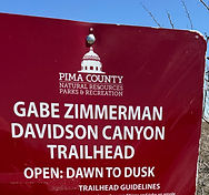
Gabe Zimmerman Trail

Trail Facts at a Glance
Name: Name: Gabe Zimmerman Davidson Canyon Trail
Location: 16248 E Marsh Station Rd., Vail, AZ 85641
Trail length plus more:1.2 miles roundtrip without a permit (utilizing only the section of the Arizona Trail) or 2.1 miles by adding sections of Ciénega Creek with a required permit. Gain 145’, Elevation 3300’, grades > 8%
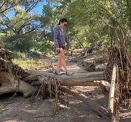
Trail surface: Rugged natural surface, sand deeper than 2”, some wet creek crossings and muddy sections
Parks agency: Pima County Conservation Lands and Resources
Contact: 520-724-5000
Parking fee: None
Trail hours: Sunrise to sunset, daily
Transit: None
Date of last visit: November 8, 2025
Disclaimer:
The information provided is for general guidance only and may not reflect current conditions. Users must assess trails for themselves, consider their own abilities, and assume all risks associated with trail use. Tucson AccessTrails, a nonprofit corporation, is not responsible for any injuries or incidents that may occur. Always use caution and prepare appropriately when visiting trails.
Description:
Overview
A 1.2-mile roundtrip hike to Ciénega Creek with a perennial stream and shady cottonwood trees
The trail overlaps with a segment of the 800-mile Arizona Trail
Scenic highlights include wildlife, wildflowers and flowing water
Parking, Restrooms & Amenities
Accessible parking spaces, an accessible port-a-potty, and a shaded picnic table
Use the trailhead to the left side of the lot to hike north toward Ciénega Creek
No permits required for day hiking on the Gabe Zimmerman or Arizona Trail
A free day-use permit is required to explore along Ciénega Creek
Dogs are allowed on leash
Trail Route
Trail is rocky with slopes greater than 8% and sand deeper than 2" in places
With a permit, hikers can explore the creek bed, requiring multiple wet crossings
Muddy areas can be slippery and may cause falls
Trail can be challenging, especially during wet or hot weather
Hiking under a railroad bridge can be noisy during passing trains
Photo Tours by Topic

Overview

Location and Arrival

Amenities and Features

Trail Characteristics
Signage and Wayfinding
Operations and Maintenance

Enjoy a 2-minute virtual visit to enhance your trail experience

