
Tucson AccessTrails
Explore Regional Trails and Parks

Sentinel Peak Park

Trail Facts at a Glance
Name: Sentinel Peak Park
Location: 1001 S. Sentinel Peak Rd.
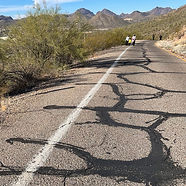
Trail length plus more: 2.4 miles roundtrip, Gain 300’, Elevation 2600’, Width 10’, shared with cars and cyclists, slopes > 8%, trail width 10’
Trail surface: Paved asphalt, with rugged dirt trails leading to picnic areas and overlooks
Park agency: City of Tucson, Parks and Recreation
Trail Contact: 520-791-4873
Parking fee: Free
Trail hours: Sunrise-Sunset
Vehicle Access: Monday: No vehicle access; Tuesday-Thursday: 2 p.m.-sunset; Friday-Sunday: 11 a.m.-sunset
Mission Garden hours: Wed to Sat; Oct to Mar, 8am – 2pm; Apr to Sept, 8am – Noon
Mission Garden location and contact: 946 W. Mission Lane, 520-955-5200
Transit: None
Date of last visit: 28 December 2023
Description
Overview
Sentinel Peak, also known as “A” Mountain, offers a mix of exercise, history, and panoramic views of Tucson
The 2.4-mile hike loops around a 2,900-foot peak once used as a lookout by settlers as early as the 9th century
The peak is known for the 150-foot-tall stone letter “A”, built by University of Arizona students in 1915
Parking, Restrooms & Amenities
Accessible parking available at both lower and upper lots
No restrooms or drinking water along the trail
Amenities include only a few benches, ramadas, and picnic tables
No shade, and the black asphalt makes afternoon hikes very hot and dry
Dogs on leash are welcome
Trail Route
The trail is a paved road connecting the lower parking lot (trailhead) to the upper parking lot (summit)

Enjoy a 2-minute virtual visit to enhance your trail experience

Disclaimer: The information provided is for general guidance only and may not reflect current conditions. Users must assess trails for themselves, consider their own abilities, and assume all risks associated with trail use. Tucson AccessTrails, a nonprofit corporation, is not responsible for any injuries or incidents that may occur. Always use caution and prepare appropriately when visiting trails.

Photo Tours by Topic

Overview

Location and Arrival

Amenities and Features
Trail Characteristics
